
RwandaNorthern Province
Ubuvumo Nyabikuri-Ruri
Longest surveyed cave in Rwanda.
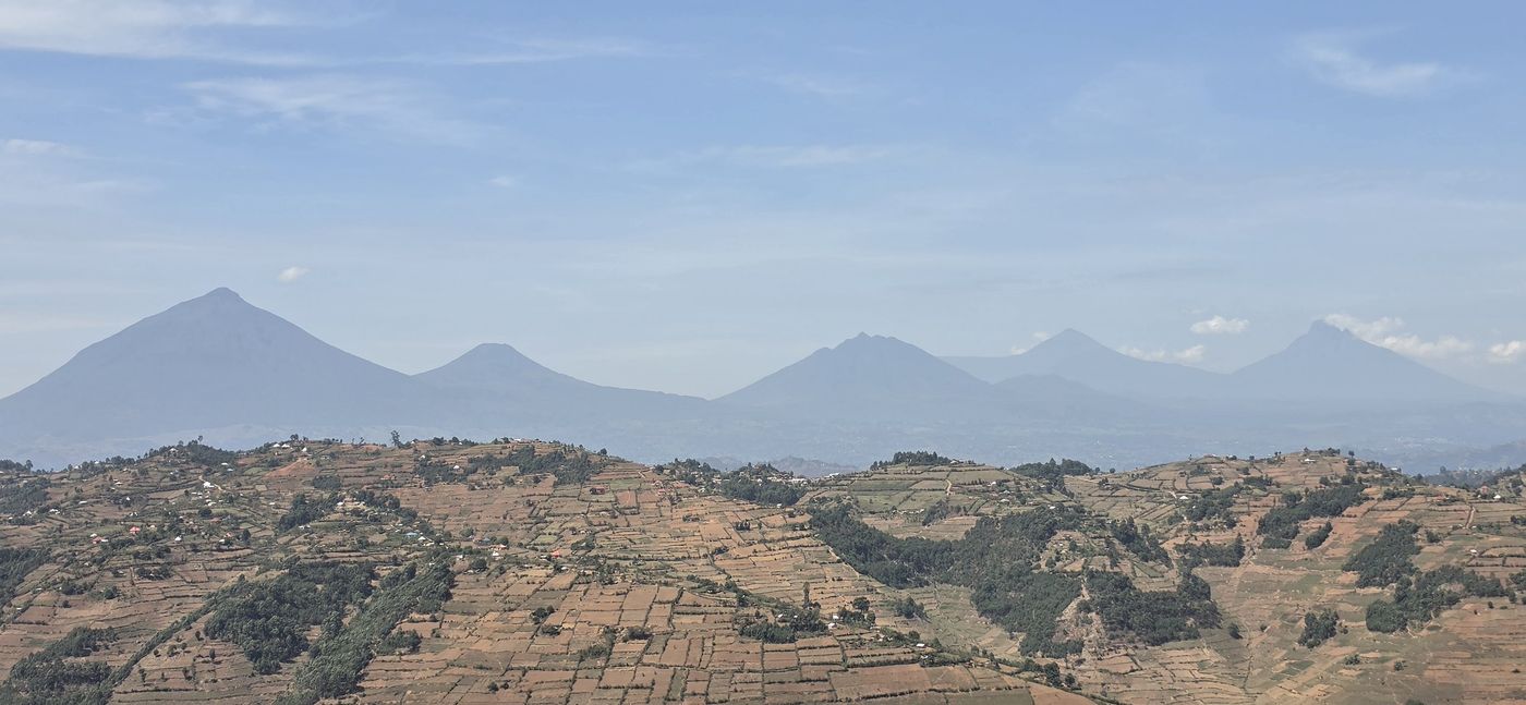
Walk through lava tubes beneath the Virunga volcanoes. Uganda's longest cave was only mapped in 2022.
Beneath the potato fields at the foot of the Virunga volcanoes lies one of East Africa’s least explored frontiers: a network of lava tubes that, in Uganda, had never seen a dedicated caving expedition until December 2022. For travellers, this is lava cave exploration and caving in Uganda and Rwanda at the very start of its story.
The entrance looks like nothing at first. A round collapse in a farmer’s field, 10 to 20 metres across, ringed with maize and Irish potatoes. Sometimes it is just a hole less than a metre wide, right in the middle of a plot. Then you drop in, switch on your headlamp, and the field gives way to a black tunnel 10 metres wide and 5 metres high, its half-dome ceiling sculpted by rivers of molten rock that drained away thousands of years ago.
Most visitors come to these mountains for the mountain gorillas, whether on Mgahinga in Uganda or in Volcanoes National Park in Rwanda. Few realise that the ground beneath the trekking trails is hollow. For adventurers who want something genuinely new, the lava caves of Rwanda and Uganda are as close to virgin territory as it gets. This guide covers the caves one by one, the life and history inside them, a sample ten-day route, and how to go safely and responsibly.
The Virunga caves are lava tubes: hollow channels left behind when the surface of a lava flow cooled into a hard roof while molten rock kept flowing underneath, then drained away. Geologists also call them lava caves or volcanic caves, and local villagers in Kisoro call them urutare, meaning “rock”.
The Virunga chain stretches about 80 km from the Cyanika border to Lake Kivu, with eight volcanoes along the Rwanda–Uganda–DRC border. The name comes from the Kinyarwanda word ibirunga, meaning “volcanoes”. Geologically they sit on the western branch of the East African Rift. On the Uganda–Rwanda border stand three extinct stratovolcanoes: Muhabura (4,127 m), Sabyinyo (3,611 m, the oldest) and Gahinga (3,470 m), which you can read about in our Mgahinga guide.
The 2022 expedition noticed that most Ugandan tubes sit between 2,100 m and 2,300 m. Their theory: at this altitude the slope angle is just right for lava tubes to form. The tubes all run roughly north–south, following the downhill path of the ancient flows. Larger lava fields are rare elsewhere in Uganda, so the Virunga foothills are likely the country’s main lava cave zone.
Rwanda has the developed show cave and the long systems; Uganda has the raw, barely mapped frontier. Visit Rwanda counts 52 caves in the Northern Province with 15.2 km of passages. In Uganda, a team led by Joerg Dreybrodt surveyed 23 caves totalling about 3 km in seven days in December 2022, in a 16 km by 8 km zone between the Cyanika border and Kisoro town. Before that, Uganda’s longest known cave was Garama at 324 m.
Longest surveyed cave in Rwanda.
Show cave with 31 entrances and a bat colony.
Second-longest in the 2003 survey.
Uganda's longest cave; 8 m wide portal and old pottery.
Tube up to 15 m wide with a small labyrinth.
Horseshoe bats and snails.
Batwa cultural and ceremonial site.
Community-run visitor cave.
Three bat species.
Tight entrance and crawls under hanging roots.
Harvestmen and millipedes.
Cave-adapted crickets.
Ugandan lengths are from the 2022 expedition report; Rwandan lengths come from the published surveys linked in this guide. The “suggested level” is our reading of each cave’s description, and your local guide confirms it before you go.
Musanze Cave is the easy entry point. It runs about 2 km, has 31 entrances (mostly roof collapses) and a main portal described as “the size of a cathedral”, with light shafts and a sizeable bat colony. It opened to the public in 2013 and is visited only on guided tours of about two and a half hours, booked through the Rwanda Development Board or a tour operator (Visit Rwanda, Showcaves.com). It sits close to Volcanoes National Park, so it pairs easily with a gorilla trek.
For serious cavers, the region holds much more. Swiss-German expeditions led by Michael Laumanns between 2003 and 2007 mapped dozens of tubes, some several kilometres long, with passages 10 m wide and 8 m high running for kilometres. Ubuvumo Nyabikuri-Ruri (3,384 m, surveyed in 2004) is the longest single cave found in Rwanda.
Around Kisoro, in far south-west Uganda, village caves sit in fields between the Cyanika border and Kisoro town. Urutare rwa Sooko (1,025 m) is the longest, with an 8 m wide portal, fragments of old pottery at the entrance and red pahoehoe lava inside. Urutare rwa Ruhengo is run as a visitor experience by Amajambere Iwacu Community Camp. Urutare rwa Kararama has an entrance hole under a metre wide in a field, then crawls beneath hanging roots. Garama Cave lies inside Mgahinga Gorilla National Park and is visited on the Batwa Trail (see Culture and history).
Resting from the caves? The same hills around Kisoro are good riding country; see our cycling guide for Lake Mutanda and Kisoro.
Schematic map drawn from the survey coordinates of the 7 caves whose positions are confirmed. Sooko and Cugyi lie only about 200 m apart, so their pins are spread slightly. The other five caves are not shown because their coordinates are still being confirmed. This map is not for navigation; your guide takes you to each entrance.
These shallow tubes are surprisingly full of life, and almost none of it has been studied. Lava cave biology is a young science, pioneered in Hawaii, the Canary Islands and the Azores; Sub-Saharan Africa has seen little beyond bat surveys. Roots dangling through the ceiling and debris washed in by rainy-season streams feed a rich food web. The 2022 team logged every sighting in the Cave Life App, but took no samples because a fauna export permit had not been granted. That means species new to science may be waiting down there.
If you go, record what you see in the Cave Life App and share photos with local partners, such as Rwanda’s Center of Excellence in Biodiversity. Every observation helps map this unknown ecosystem. For the wider picture of wildlife above ground, see our guide to Uganda’s national parks.
These caves are not just geology; people have used them for more than a thousand years, as homes, hiding places and sacred sites.
Visit with respect. If you come across remains, do not touch, move or photograph them for fun, and tell your guide.
The local community is part of the adventure. Villagers in Kisoro guided the 2022 team to entrances, often having explored only by mobile phone light. Bringing spare headlamps and inviting them in turned a survey into a shared discovery. Our guide to responsible and sustainable safari travel explains how to choose trips that leave money and respect in the places you visit.
A cross-border lava cave trip can be done in 10 days: a few days around Musanze in Rwanda, then over the Cyanika border to Kisoro, Uganda. This is a suggested shape, and we adjust it to your dates, group and experience.
Want this route with both gorilla permits, or one country only? Read how to combine Uganda and Rwanda gorilla trekking, compare Uganda and Rwanda, or browse our ready-made itineraries.
The East Africa Tourist Visa covers Rwanda, Uganda and Kenya. Fees and rules change, so check current ones before you go. Our East Africa Tourist Visa guide explains how it works, and visa requirements for five destinations covers the rest of the region.
Amajambere Iwacu Community Camp near Mgahinga offers huts, camping, meals and cultural walks, and can arrange cave guides. Musanze has everything from campsites to luxury lodges. See our lodges, and the “where to stay” sections of the Mgahinga and Volcanoes National Park guides.
A 4x4 is essential in Uganda: main roads are tarred, but side tracks are potholed dirt. In Rwanda, Kigali to Musanze is a 2–3 hour drive on good tarmac. For the border step, read our border crossing guide.
Musanze Cave is booked via the Rwanda Development Board. Survey or research work needs official permission, and Rwanda’s process can be slow, so apply months ahead. Caves inside Mgahinga National Park need Uganda Wildlife Authority approval. If you add gorillas, see how and when to book gorilla permits and our permits page.
A local guide is essential: entrances are hidden in private fields and villagers know where they are. Trips run with local guides. See our licence and how we protect your trip.
Volcanic ground stays firm after rain, so even the short rains of November–December are workable. Gorilla trekking and volcano climbs are more comfortable in the drier months; our best time to visit Uganda guide has the detail.
Your gorilla trek and the rest of the trip need their own kit; see the East Africa safari packing list.
No for Musanze Cave, which has guided 2.5-hour tours. Village caves in Uganda include crawls, so you need moderate fitness.
Trips run with local guides. Bat roosts call for masks, and security near the DRC border is checked before every trip.
All year. Volcanic ground stays firm even in the November–December rains.
Yes. The caves are close to Volcanoes National Park (Rwanda) and Mgahinga National Park (Uganda). See gorilla trekking safaris for how we combine them.
The East Africa Tourist Visa covers Rwanda, Uganda and Kenya. Read our East Africa Tourist Visa guide and check current rules before you travel.
Rates depend on group size, dates and route. Use Get the rates for a quote, and we reply within 24 hours.
A lava tube is a hollow channel left behind when the surface of a lava flow cools into a hard roof while molten rock keeps flowing underneath, then drains away. Parts of the roof can later collapse and open entrances.
Urutare rwa Sooko near Kisoro, at 1,025 m. A 2022 expedition surveyed it; before that, Garama Cave at 324 m was the longest known cave in Uganda.
Yes. Garama lies inside Mgahinga Gorilla National Park and is visited with Batwa guides on the Batwa Trail. Caves inside the park need Uganda Wildlife Authority approval.
Bats can carry viruses, and Egyptian fruit bats were linked to a 2008 Marburg case at Python Cave in Queen Elizabeth National Park. Wear an FFP2/N95 mask in any bat roost, avoid touching bats or guano, and wash or change clothes afterwards. Authorities tested the bats in Garama and reported them virus-free.
Tell us who is travelling and when. We design the route, arrange the local guides and send your rates within 24 hours.
If you would rather talk now, write to [email protected].
| For | Read | What it covers |
|---|---|---|
| The parks | Mgahinga Gorilla National Park · Volcanoes National Park · Bwindi sectors | Gorillas, volcanoes and the Batwa Trail around the caves. |
| Every park | Uganda national parks · Rwanda national parks compared | Where else to go, and how to choose. |
| Border and visa | Uganda–Rwanda border crossing · East Africa Tourist Visa · Visa requirements | Crossing at Cyanika and entry rules. |
| Gorillas | Gorilla and chimpanzee trekking in Uganda · What happens on the trek · Fitness for trekking | The add-on most cave travellers choose. |
| Routes | Combine Uganda and Rwanda · Uganda vs Rwanda | Two countries, one trip. |
| Health and safety | Vaccinations · Travel insurance · Is East Africa safe? | Before you travel. |
| More in Uganda | Uganda: a local specialist’s guide · Night drives and walking safaris | Other ways to see the country on foot. |
| Planning | First-time safari planning · When to book · Uganda · Rwanda | From dates to booking. |
On a rest day near Kisoro? See our cycling safari guide for Lake Mutanda.
New to safaris? Start with What Is a Safari? Types of Safari and How to Choose.
Get the ratesTell us your dates and interests — a destination specialist replies within 24 hours.
Start Planning